June 05, 2024

")
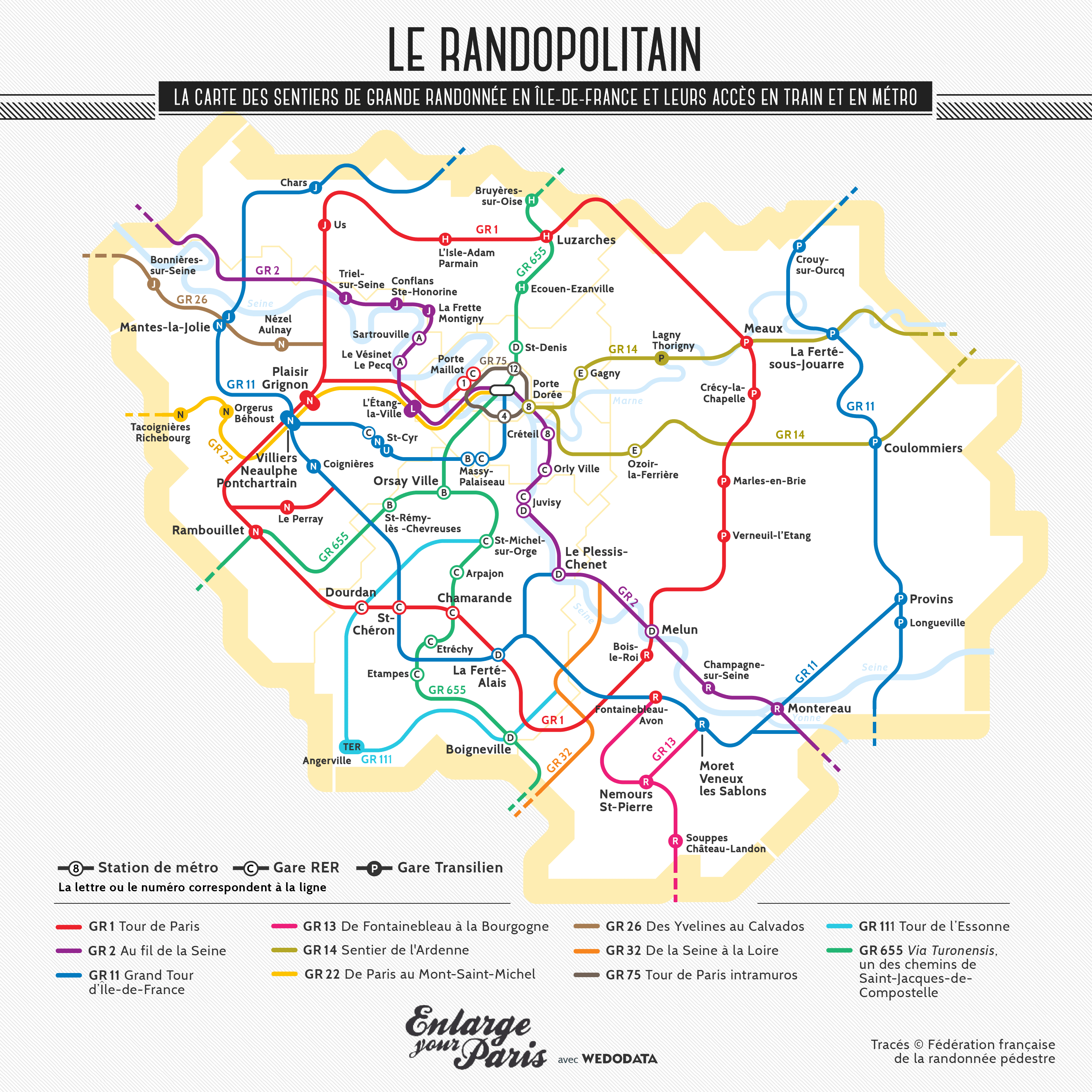
Eleven major hiking trails crisscross the Greater Paris area. To better visualize them, Enlarge Your Paris has created, with Wedodata, a data visualization expert company, a map just like the one you find for the metro and suburban train network: the "Randopolitain." The routes were suggested by the French Hiking Federation and the Paris Regional Hiking Committee, keeping in mind access to the train and metro stations.
These more than 100 hikes have been designed, having in mind the Olympics since this great sporting event should entice people to practice more and more sports.
Click to enlarge
GR1, Tour de Paris
After the GR3, from La Baule to Mont Mézenc, it is the second major hiking trail in France.
The GR1 is a 540 km loop around Paris, starting from Porte Maillot, the major connection hub recently opened as part of the Grand Paris Express, the huge extension of the public transport system.
GR2, Along the Seine
GR2 starts from Dijon to reach Source-Seine, where the Seine originates, and then follows the river to Le Havre. A total of 858 km, including landscapes in Île-de-France like the Vexin Français Natural Park (Val-d’Oise) and the village of Samois-sur-Seine (Seine-et-Marne).
GR11, Grand Tour of Paris Region
The 645 km GR11 connects the four natural parks of Paris Region: Haute Vallée de Chevreuse, Vexin Français, Oise-Pays-de-France, and Gâtinais Français.
GR13, From Fontainebleau to Burgundy
Before crossing the Morvan region, the 423 km GR13 starts with a warm-up in the Fontainebleau Forest (Seine-et-Marne).
GR14, Ardennes Trail
Starting from Porte Dorée in Paris, the GR14 ends at the gates of Belgium after 579 km, featuring a lovely walk along the Marne River in Saint-Maur (Val-de-Marne).
GR22, From Paris to Mont-Saint-Michel
The GR22 connects two French icons, the Eiffel Tower and Mont-Saint-Michel, along a 565 km route that includes the landscapes of the Haute Vallée de Chevreuse Natural Park (Yvelines).
GR26, From Yvelines to Calvados
From the banks of the Seine in Villennes (Yvelines), the GR26 winds its way to Deauville over 305 km.
GR32, From the Seine to the Loire
The GR32 begins on the banks of the Seine in Saint-Fargeau-Ponthierry (Seine-et-Marne) and extends 135 km to the Loire after crossing the Gâtinais Français Natural Park, spanning Essonne and Seine-et-Marne.
GR75, Tour of Paris Intramuros
Nominated for the 3rd edition of the "GR Preferred by the French," with a new voting taking place in November 2014, the GR75 is a 100% Parisian route created in preparation for the Paris 2024 Olympic Games.
GR111, Tour of Essonne
Stretching 157 km, the GR111 offers an opportunity to explore the landscapes and sights of Essonne, such as the Château de Dourdan and the Saint-Blaise Chapel painted by Jean Cocteau in Milly-la-Forêt.
GR655, Via Turonensis
As one of the four hiking routes leading to Saint-Jacques-de-Compostela, it crosses Paris Region from north to south.
Information and trail maps at www.ffrandonnee-idf.fr
Twice the size of Paris, the Fontainebleau Forest is a hiker's paradise / © Jérôme Bon (Creative commons / Flickr)